
How Benin’s New Water Atlas is Powering Climate Resilience Planning

Benin’s Nationally Determined Contribution (NDC) and National Adaptation Plan (NAP) highlight water insecurity as a top climate risk. Growing climate variability is putting pressure on already limited water resources and affecting agriculture, energy production and public health.
For years, planning and investment decisions relied on outdated hydrological information. The last nationwide mapping of Benin’s water resources was completed in 2008, leaving officials without the accurate, accessible data needed to design, finance or monitor adaptation measures. To address this information gap, Benin has updated its hydrographic atlas with support from the Netherlands mobilized through the NDC Partnership. A national consultancy firm of water and geographic information system (GIS) specialists led the technical work, supported by SNV Netherlands Development Organization, the Embassy of the Netherlands and the NDC Partnership Support Unit. The Directorate General for Water (DGEau) provided project oversight, while the NDC Partnership’s in-country facilitator coordinated stakeholder engagement to ensure strong national ownership.
The new, nationally validated hydrographic atlas will serve as a critical decision-support tool guiding how Benin plans and finances water resilience across sectors.
Closing the Water Data Gap in Benin
As part of NDC implementation planning, the Ministry of Energy, Water and Mines identified major data and capacity gaps in the water sector, working closely with the Ministry of Living Framework and Transport and development partners.
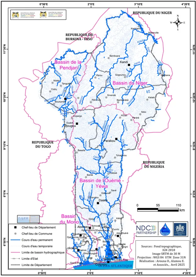
Using satellite imagery, high-resolution digital terrain models and more than 320 field-based global positioning system (GPS) surveys, the technical team produced a GIS-based database of rivers, reservoirs (including dams, ponds, retention basins and natural pools), drainage networks and catchment areas. The updated hydrographic atlas is now the most complete and accurate baseline of Benin’s surface water systems, showing spatial water data at a level of detail not previously available.
DGEau and regional basin committees led validation workshops across the four main watersheds — Ouémé-Yéwa, Mono-Couffo, Niger and Volta — involving prefectural authorities, municipal technicians, basin agencies and civil society. These consultations helped validate spatial data collected and confirm local water management priorities.
“This mapping exercise has given Benin verified and accessible data on our surface water systems for the first time in more than a decade,” says Kolawole Saïd Hounkponou, the DGEau General Director. “It strengthens coordination across national, regional and local levels and gives institutions the data they need to make informed decisions related water resources.”
Evaluating Long-Term Trends
The new hydrological mapping integrates historical records from 1961 onward with current spatial data. This allows DGEau to analyze long-term trends and understand how climate change might be reshaping water availability.
Between 1961 and 2020, temperatures increased significantly across all basins, intensifying evaporation and seasonal water loss. Updated river flow analyses show declining flows in most basins, underscoring growing pressure on surface water during dry seasons.
At the same time, the inventory of water capture points — including dams, ponds and retention basins — expanded from 187 identified in 2008 to 1,085 in 2025. This increase reflects both a rising demand for storage and a significantly improved monitoring methodology that now captures smaller water bodies previously unmapped.
The consolidated dataset gives planners a clearer understanding of emerging vulnerabilities and where adaptation investments can have the greatest impact. By engaging in this work, DGEau has also built its capacity to model hydrological flows, assess climate risks and guide infrastructure development. The data will directly support the NAP water component, informing investment decisions through the National Environment and Climate Fund (FNEC) and water resource allocation across key national economic sectors like agriculture, mining and industry.
Insights from the atlas are now directly informing Benin’s NDC 3.0 and NAP updates. This is helping to institutionalize the new data as part of ongoing adaptation planning.
"This new atlas is a strategic asset for Benin,” says Wilfried Mongazi, NDC Partnership Focal Point for Benin. “For the first time since 2008, we have a reliable national database that allows us to manage our resources proactively and guide infrastructure planning with far greater precision."
Leveraging Water Data for Investment
Reliable, detailed spatial water data is critical to attract investment in water actions aligned with national climate priorities. The updated hydrographic atlas gives ministries, project developers and financiers an accurate baseline to identify priority zones for climate resilient water infrastructure, irrigation and watershed management.
The next steps include expanding mapping to groundwater resources, integrating water data into the national water monitoring system. Together, these actions will help translate data into prioritized bankable proposals and long-term investment pipelines.
“The project enables data-informed investments by showing exactly where Benin needs to target its efforts,” says Olaodjewou Odjougbele, the NDC Partnership in-country facilitator. “This early support is unlocking long-term opportunities for climate resilience.”
Toward Long-Term Water Resilience
Maintaining and updating the atlas will now form part of DGEau’s ongoing water monitoring mandate. The process will now be anchored in its operational systems and supported by national and partner resources. Benin’s updated hydrographic atlas lays a foundation for climate-smart, data-informed water management and sectoral investments.
-
Visit the Benin country page.